by Gill Caves, Group Footpath Secretary
To email the footpath secretary, click here.
Meirionnydd footpaths
Meirionnydd has a rich network of Public Rights of Way - footpaths, bridleways and byways - covering around 1500 miles. There are low level and high level routes, easy and not so easy, though fields and woodlands, alongside rivers and coasts and up into the mountains. Our Rights of Way are classed as “highways” and afforded the same protection in law as the roads we drive on. Like our roads, they are kept open and usable by the local highways authority, the county (or unitary) authority, but with limited resources Gwynedd County Council is hard pressed to keep up with the enormous amount of work involved. The most popular and well used paths are, quite rightly, prioritised by both the Council and the Snowdonia National Park Authority, but inevitably some of the lesser paths can become blocked or fall into disrepair. However, this should not deter you from bringing problems to the attention of the Council especially if the problem could pose a danger to the path user and ultimately it is important to have a good overview of the state of the paths especially when it comes to bidding for funds. We are grateful to the Rights of Way staff from both Gwynedd Council and Snowdonia National Park who work extremely hard and diligently on all of our behalves to try and maintain a safe and accessible network for us all to enjoy.
Reporting footpath problems
Gwynedd Council has two ROW teams; one covering the southern part of the County (stretching from the Dyfi Bridge at Machynlleth and then northwards roughly to the north of Bala; Blaenau; and the Cnicht Ridge) and the other covering the County area to the north. As the Meirionnydd Group, our main interest is for paths in the south of the County whilst the Eryri Ramblers group more concerned with the paths in the north of the County. If you come across any problems while walking on Gwynedd's Rights of Way, such as as obstructions or faulty stiles or gates, you can report them direct to the council by phone (01766 771000) or by using this online form. Alternatively if the path is within Meirionnydd you can report the issue to me using the ‘footpathsec’ address at the top of the page and I will pass the information on. Please be sure to tell us the exact nature of the problem and provide a grid reference of its location. A photograph is also useful. If you cannot provide a grid reference we need a good enough description to pinpoint the location. If the problem is in the north of the County then you can report it to Eryri Ramblers via their website eryriramblers.org although wherever the problem is please do go direct to the Council if it is one which causes an immediate hazard to the user.
Latest footpath news August 2026 - footpath closures.
From time to time it is necessary for the Highways Authority (Gwynedd Council) to close a right of way temporarily, usually for reasons of public safety or to enable works to be carried out. Temporary closure orders are made for 6 months but the closures are often in force for a much shorter period. However, if the closure is required beyond 6 months then the Highways Authority (Gwynedd Council) need to make an application to the Welsh Government to approve an extension. During the closure period there should be notices and a map on site advising of the closure and the alternative route(s).
Sometimes, if intermittent works are going on near a right of way that could present a health and safety issue for users, rather than closing the path by notice, contractors can decide to have workers on site to direct the public around the closure or halt works to allow safe passage. Please obey instructions from contractors in these instances. However, should you come across any closed paths that do not have official public notices from Gwynedd Council displayed, or contractors on site to direct you, please let me know.
Details of closures in the Meirionnydd area about which we are aware are:
1) Tree Felling Works: Natural Resources Wales is undertaking a comprehensive and ongoing programme of tree felling throughout the County where there are public rights of way (ROW). In order to avoid unnecessarily closing the ROW for long periods of time, and where it is possible to make them available to use when works are taking place, there will be contractors on site to alert users of the path. For your own safety please follow any instructions that you are given and adhere to all warning signs. In some area path closures will be necessary and details will appear below.
2) Aberllefenni: The footpath between grid ref SH 768 134 (edge of Open Access area) and SH 776 120 (Ratgoed) had to be closed following storms last year. An alternative permissive path has been provided from SH 774 139, some 850 metres to the NW, rejoining the footpath at SH 775 124. Please use this until the definitive path is properly re-opened.
3) Trawsfynydd footpath 56: The bridge which crosses the Afon Prysor at SH 72914 35202, east of Lake Trawsfynydd, remains closed due to the poor condition of the decking on the bridge. To avoid this section of FP 56 when travelling between Hafod Wen and Swn y Nant it will be necessary to leave the path at SH 730 356 west of Hafod Wen and proceed in a generally SW direction to the path junction at SH 725 352 . Proceed SE along the river to cross at SH 725 352 and continue in a generally SE direction to the meet the minor road. Head west to the A470.
4) Ganllwyd FPs 56, 58 and 61: Due to tree harvesting works the following sections of footpaths in the Community of Ganllywd will be closed with effect from 14th September 2026. The work is expected to last 6 months and unfortunately there are no alternative footpaths to use during the closure period. The sections of paths affected are:
a) Public Footpath no 56 from grid ref SH 748 250 at its junction with the highway 320m south south-west of the property Yr Hen Sgubor, in a generally north-westerly direction for approximately 700m to grid ref SH 746 255 at the junction with the highway 90m north-east of the property Hen Dôl Frwynog.
b) Public Footpath no 58 from grid ref SH 748 256 at the junction with the Unclassified Road 80m west of the property Hermon Bungalow, in a generally south-westerly direction for approximately 1400m to grid ref SH 741 247 at the junction with the highway approx. 450m north north-east of the property Maes yr Eglwys Wen.
c) Public Footpath no 61 from grid ref SH 745 248 at its junction with Footpath Ganllwyd 58 approx 800m north-east of the property Maes yr Eglwys Wen, in a north-easterly direction for a distance of 360m to grid ref SH 748 250 at its junction with Footpath Ganllwyd 56 and the forest track 280m south south-west of the property Yr Hen Sgubor.
Other news
Footbridge at Trawsfynydd: An inspection in 2022 of the footbridge at Trawsfynydd revealed a number of structural and safety related issues. Magnox Ltd, who are responsible for the bridge, therefore took the decision to close it pending a review of next steps. The bridge is not a Right of Way nor in the control of the highway authority (Gwynedd Council) so if you have any concerns about the continuing closure please address these to Magnox direct or to
New sign posted walks at Dinas Mawddwy: Eight circular waymarked self-guided routes have been developed by social enterprise Cwmni Nod Glas in Dinas Mawddwy with funding from the Welsh Government, the EU and other partners. The paths explore intimate valleys, tumbling streams, shady woodlands and wild moorland with magnificent views and vary in length from 1.7 miles to 12.5 miles. All the walks follow public rights of way and are waymarked. The routes are available to download and print from the Dinas Mawddwy Walks and Trails website and are also available to purchase from various outlets in Dolgellau and Machynlleth. Five of the routes start and finish in Dinas Mawddwy whilst others start and finish in three other nearby villages – Llanymawddwy, Mallwyd and Aberangell.
Before and after pictures
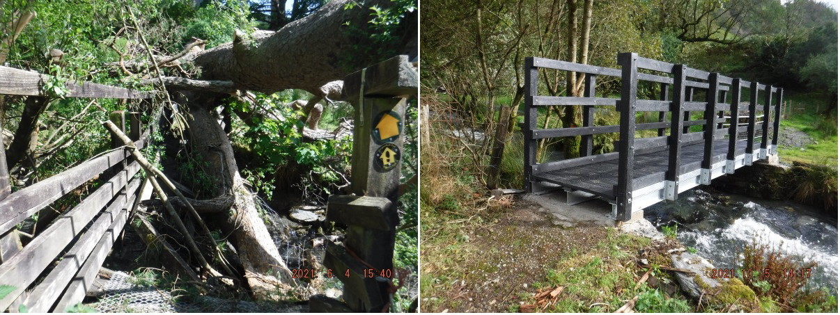
Just to illustrate that reporting path problems is well worth while here are some "before and after" pictures of a collapsed bridge in the popular Cwm Ratgoed. It was replaced within a matter of weeks.
Path Maintenance Workday near Llanfachreth
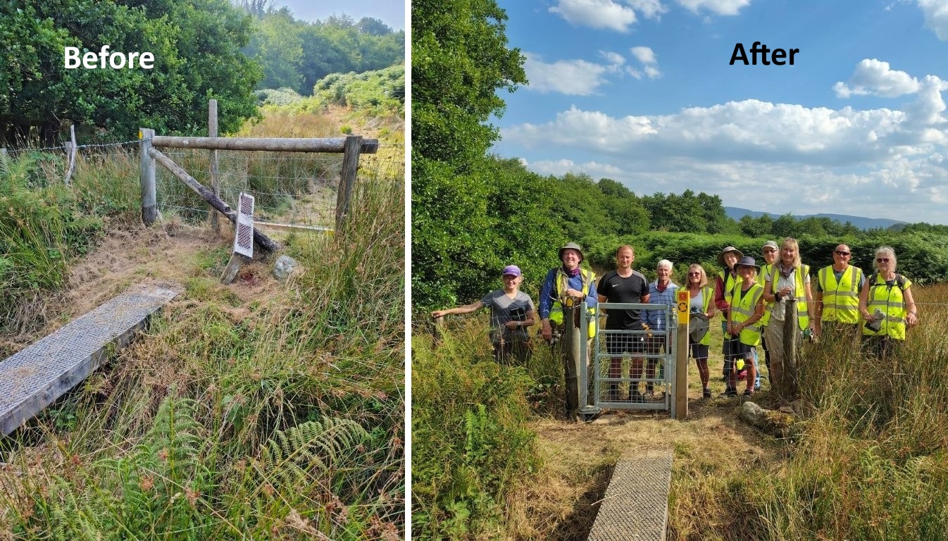
Undeterred by it being one of the August days on record, 9 of our path maintenance volunteers turned up to undertake some improvements on a path near Llanfachreth, Gwynedd. Working alongside Gwynedd Council’s Rights of Way Officers and their contractors we replaced 2 broken stiles with self closing gates, installed a number of way marker posts and cut back vegetation. There had been plans to try and improve the drainage on some sections of the path but the long dry conditions of previous weeks meant that the problem areas were not evident. The contractors will return to the site later in the year to complete this aspect of the work. However, on the workday, it was definitely a question of many hands making light work - although perhaps 'light' is not the right word. The ground was baked hard in places which meant digging was a challenge, but with a good number of people available we were able to split into two teams and also switch between the type of work that needed to be done. It was a very full day but satisfying. The section of path worked on was about 0.3 miles in length but since it was in the middle of a longer path it means that almost a mile of path is now available and much easier to walk. We had been successful in applying for a grant from the Ramblers Accessibility Fund to fund the work. This is the third time we have been awarded funding. It means that the limited resources that the ROW team at the Council has for undertaking path improvements, can be stretched a little further. If you want to see the results for yourself the stretch of improved path is between SH 76251 21963 and SH 76393 21529. Hopefully we can use it on future walks. A big thank you to all those who helped on the day and to those who were on standby to help had we had to re-schedule the day.
We are very fortunate to have a number of members from within our group to call upon to help for path maintenance but we can always accommodate more, so if you would like to help on a future work day, or there are paths that you come across a path that you think would benefit from some maintenance (but without the use of contractors and machinery), then please email me at footpath secretary.
Before and after photographs showing the results of the workday are below. Click here to see lots more photos.
Gill Caves, Footpath Secretary